
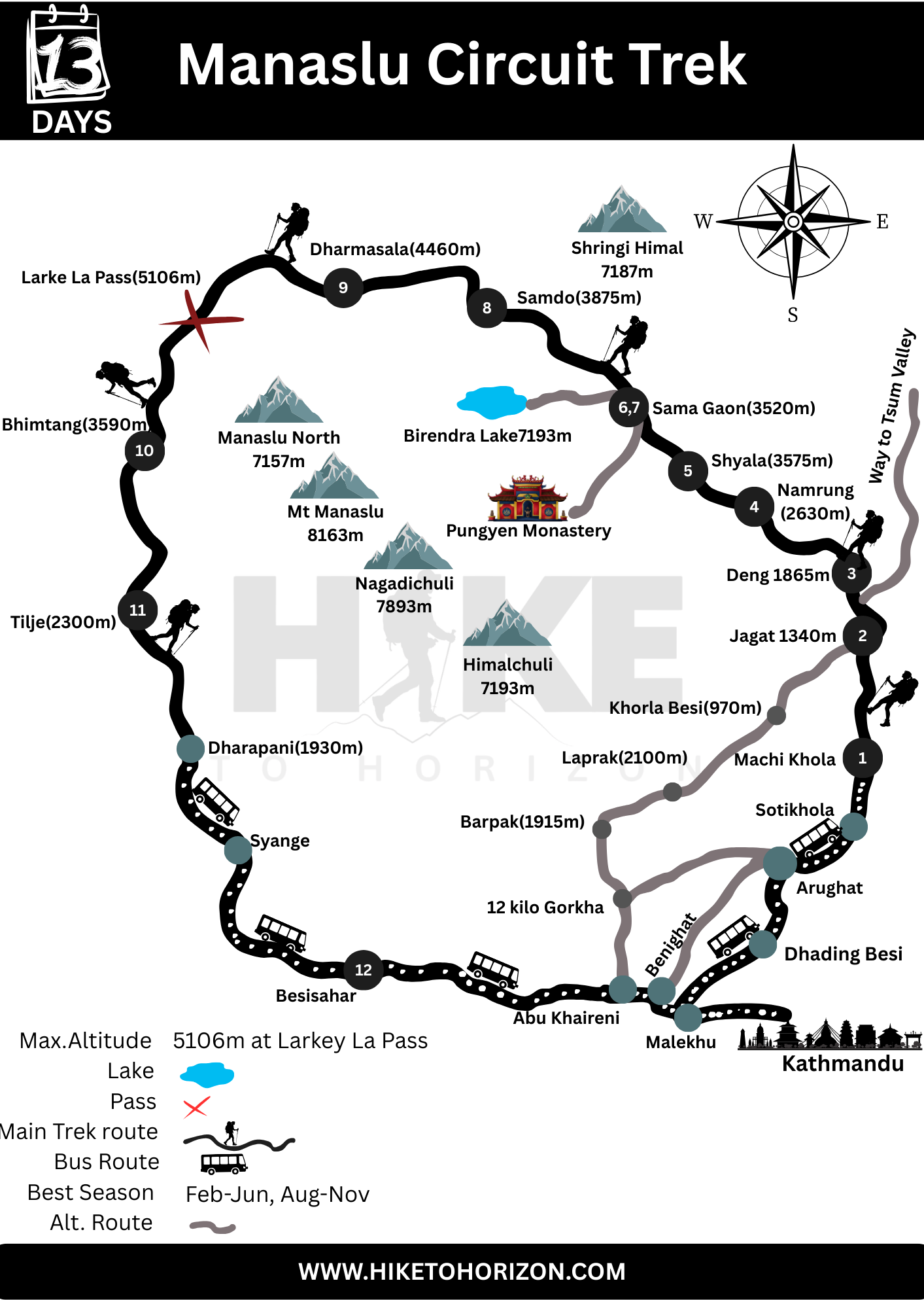
The Manaslu Circuit Trek is one of the most iconic trekking trails, following the Budhi Gandaki River, crossing the challenging Larkey La Pass, and blending Tibetan culture and traditions. Following the proper itinerary and the Manaslu Circuit Trek map makes trekking smooth and ensures it can be completed on time. Larkey La Pass is the most highlighted destination of this trek. Traditional villages like Samdo and Samagaun are the major attractions where Mt. Manaslu, Himlung, Choe Himal, and Annapurna II are the peaks visible during the iconic trek.
Why Manaslu Circuit Trek Map important?
The trek map is one of the most important tools on any trek. Here are the reasons why it plays a vital role for the trekkers:
With a Manaslu circuit trek map, trekkers can easily navigate the route and enjoy the stunning views along the way.
- Keep trekkers on track
- Improves safety and security.
- Elevation can be known.
- Helps in day-to-day planning.
- Aware of the geographic context.
Why choose the Manaslu Circuit Trek Map?
The 8th-highest mountain in the world, Mt. Manaslu (8,163 m), is located here, and trekkers experience the remarkable trek to it. Similarly, the Manaslu Circuit Trek is a less crowded trek than the Annapurna and Everest Base Camp Treks. It offers a dramatic landscape to the trekkers with deep gorges, glaciers, high passes, and so on. Manaslu Trek is popular among travelers due to its rich Tibetan-influenced culture and ancient monasteries.
Utilizing a detailed Manaslu circuit trek map enhances your trekking experience significantly.
13-day itinerary of the Manaslu Circuit Trek based on the trek map
The Manaslu Circuit Trek map is essential for understanding the terrain and planning your daily trek schedule effectively.
Day 1: Drive to Machhi Khola from Kathmandu.
Manaslu Circuit Trek begins with an early departure from Kathmandu by road. Your journey follows the Prithivi Highway with the beautiful Trishuli River alongside. Stunning views of rural villages, terraced hills, distant Himalayan peaks, and the fresh environment far from the city will welcome you. After crossing through the place called Salyantar, you will leave the black-topped road. The road from here becomes rougher and more adventurous. From Salyantar, you can see the amazing Budhi Gandaki River, which comes all the way from the Manaslu region.
After an 8-10 hrs scenic ride through the mesmerizing landscape and rugged mountain roads, you will reach Machhi Khola, the gateway to the Manaslu Circuit. After having an adventurous day, enjoy your evening with a good meal with the soothing sound of the Budhi Gandaki River. Also, prepare for your trek, as we will leave the roadway behind us from tomorrow.
Day 2: Machhi Khola to Jagat ( 1340 m).
After having an amazing breakfast, your trek to Manaslu officially begins. The trail follows the River Budhi Gandaki and several gorges. You will encounter several suspension bridges on this day. Also, the way passes through villages like Khorlabesi and Tatopani. Tatopani is the place where natural hot springs offer a glimpse of attraction. Passing through wild forests and rocky cliffs with narrow trails, you feel like you are having a real adventure. As you gain elevation, the scenery becomes more spectacular.
Slowly and gradually following the Manaslu Circuit Trek Map around for 6-8 hrs, you will reach Jagat, your destination for that day. Jagat is the entry point to Manaslu Conservation Area. Prayer walls, traditional houses, and mountain culture start to dominate the landscape. Enjoy the peaceful environment, interact with friendly locals, and explore the village.
Day 3: Jagat (1340 m) to Deng ( 1865 m).
The trekking trail for this day takes you through traditional villages, deep rivers, and a fascinating mix of forests. The way climbs gradually uphill towards Salleri. This is the point from where snow-capped mountains will be waiting for you. After that, the trail starts to gradually descend to Sirdibas, from where you cross the suspension bridge over the Budhi Gandaki River. The route continues towards the largest Gurung settlement, a village called Philim. After crossing Philim, the trail enters a dense rhododendron and pine forest.
The more you hike, the more you feel the influence of Tibetan culture and lifestyle. Architecture, Prayer flags, and the tradition are the reasons behind it. Hiking for 6-8 hrs, the day comes to an end at Deng village, which is surrounded by mountains and forest. From here, the taste of food starts to feel like you are in the mountains.
Day 4: Deng(1865m) to Namrung (2630m).
The trek begins from Deng to Namrung for that day. After crossing the suspension bridge of Budhi Gandaki several times, the route takes you through dense forest and traditional villages like Bihi Phedi and Ghap. Mani Walls, Chortens, and colorful prayer flags welcome you on the way, which reflect the growing Tibetan influence. The air becomes cooler and thinner as you gain altitude. Once trekkers reach Namrung, they will be rewarded with magnificent mountain views which are surrounded to you.
Namrung Village is known for its vibrant atmosphere, warm hospitality, and ancient monasteries. If you reach Namrung before evening, exploring the village and enjoying the spectacular Himalayan panorama would be the best idea.
Day 5: Namrung (2630 m) to Shyala (3575 m).
Mark it on your diary before your trek that this day offers some of the most breathtaking mountain gains of the entire Manaslu Circuit Trek. The trail enters through beautiful forests before reaching Liji and Sho villages. Outstanding mountain scenery, including Manaslu, Himal Chuli, and Ganesh Himal are encountered during hiking on that day. The famous monastery near Lho can be encountered on this day, which reflects the true local Buddhist Culture.
The elevation increases gradually, and the vegetation becomes sparser, and the mountain views become more dramatic and amazing. After reaching Shyala, every trekker feels like they have entered a natural amphitheater surrounded by towering Himalayan giants. One of the major attractions of Shyala village is the sunset view.
Day 6: Shyala (3575 m) to Sama Gaon ( 3520 m).
This day, the hike is relatively short in comparison to other days. You can take advantage of this by enjoying the surroundings and walking in a relaxed way. The trail passes through glacial valleys, alpine landscapes, and open yak pastures with amazing Manaslu views. After hiking for a couple of hours, you will reach the largest village of the Manaslu Region, which reflects Tibetan culture and hospitality. Visiting the monastery and exploring the village can be the things that you can do after reaching Sama Gaon.
Day 7: Acclimatization day at Sama Gaon ( 3520 m).
For a safe trek, you need to acclimatize your body to that elevation. Acclimatization day does not mean staying at a particular place or remaining inactive; a short day hike nearby is crucial on that day. There are multiple options for a hike from Sama Gaon. Pungen Monastery, Birendra Lake, or Manaslu Base Camp are some options that you can choose from. Many trekkers prefer Birendra Lake, one of the beautiful glacial lakes located close to Sama Gaon. The hike will help you to adjust your body to the elevation, and the towering peaks throughout the day are another amazing experience that you will feel for sure.
One of the crucial things that you should follow is that you have to be hydrated, and the pace should be slow at high elevation. You should not pressure your body at that elevation; it is very risky. You have to listen to your body before taking any moves.
Day 8: Sama Gaon to Samdo ( 3875 m).
The landscape becomes rugged and dramatic as you hike from Sama Gaon to Samdo. The trails follow wide alpine valleys and barren terrain on that day. Snowy peaks, magnificent views of glaciers, and a mountain valley are the major attractions of that day. On that day, you are very close to the Tibet Border, as Samdo is a traditional village rich in Tibetan culture and history. Once you reach Samdo, a short walk around the village is recommended to acclimatize your body by enjoying the Himalayan wilderness.
Day 9: Samdo ( 3875 m) to Dharamsala ( 4460 m).
This is the crucial day for the trekkers as they will gain an elevation of around 600 meters. The route steadily climbs through rugged alpine terrain to the high mountain zone. As you are at a high elevation, it is important to walk slowly and to hydrate yourself. Dharamsala is also known as Larkey Phedi, and it is the first point before Larkey La Pass.
The hike for that day is short, so you will have enough time to rest and prepare for tomorrow’s challenge. You have to prepare both mentally and physically for the next day.
Day 10: Pass Day; Dharmasala ( 4460 m) to Bhimtang ( 3590 m).
On this day, you have to wake up early in the morning. This is the most challenging day of your trek to the Manaslu Circuit. Before sunrise, you have to start your trek. On the way, ay you will encounter breathtaking views of Mt. Manaslu, Cheo Himal, Kang Guru, Himlung Himal, Annapurna II, and many more Himalayan giants. The amazing Himalayan ranges surround you once you reach the Larkey La Pass, which is covered with prayer flags.
After having successful ascents, the trail to Bhimtang from Larkey La Pass is gradually downhill. You have to be careful during your descent. The greener valley in Bhimtang will be welcoming you on that day.
As you descend, refer to the Manaslu Circuit Trek map to ensure you are on the right path back to civilization.
Day 11: Bhimtang ( 3590 m) to Tilje ( 2300 m).
As you descend, the air becomes thinner, and oxygen gradually increases. The trail passes through pine woodlands, rhododendron forests, and wildflowers. Once again, traditional charming villages begin to appear. After walking for 6-7 hrs, you will reach the Tilije Village for that day.
Day 12: Tilje ( 2300 m) to Besisahar.
This is the final trekking day of your Manaslu Circuit Trek. The trails become easier as you lose elevation, and after walking a couple of hours, you will reach the roadway. Having a couple of hours of riding through the bumpy road, you will finally reach Besisahar. It marks the official end of the trekking portion. You can have an amazing evening that day, as Besisahar is the city. Celebrate your achievement with your guides, assistant, and friends. You will have comfortable accommodation and a special dinner that you missed on your trek.
Day 13: Drive from Besisahar to Kathmandu.
This is your final day of the Manaslu Circuit Trek. After breakfast,t the drive begins from Besisahar to Kathmandu. The route connects to the same Prithivi Highway that we missed last time before our trek. It will be an almost 6-7 hrs ride to Kathmandu, where almost all the roads are black-topped. After arriving in Kathmandu, transfer to your hotel and enjoy your evening celebrating the completion of your Manaslu Circuit Trek.
Manaslu Circuit Trek can be completed in 12 days as well. Trekkers can directly ride to Kathmandu on the same day from Tilje. So if you have limited time or vacation in Nepal, then prefer the 12-day Manaslu Circuit Trek. But if you have enough time, then the 13-day Manaslu Circuit Trek would be best, and follow the above Manaslu Circuit Trek Map.
More Details on Manaslu Circuit Trek